At first glance, it seems like an obvious choice.
Polar-orbiting satellites often produce stunning Earth imagery with incredible detail. Some can even capture cloud structures, coastlines, and weather systems at resolutions far higher than geostationary satellites.
So why does LiveAtlas primarily rely on satellites like:
* Himawari-8
* GOES-East
* GOES-West
* Meteosat
* GK-2A
instead of low Earth orbit satellites?
The answer comes down to one simple word:
Continuity.
⸻
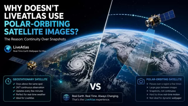
What Is a Polar-Orbiting Satellite?
Unlike geostationary satellites that remain fixed above the equator, polar-orbiting satellites travel much closer to Earth.
Examples include:
* NOAA-21
* NOAA-20
* Suomi NPP
* Terra
* Aqua
These satellites orbit Earth roughly every 90 to 100 minutes.
Instead of continuously watching one region, they travel from pole to pole while Earth rotates beneath them.
This allows them to eventually scan the entire planet.
That makes them incredibly useful for:
* climate research
* environmental monitoring
* ocean observation
* wildfire detection
* atmospheric measurements
In many cases, they produce some of the most beautiful Earth images available.
⸻
The Problem: They Don’t Continuously Watch Earth
This is where things become difficult for a real-time Earth wallpaper.
Imagine looking out your window.
Now imagine the window only opens for a few seconds every several hours.
That’s essentially how polar-orbiting satellites observe a location.
A satellite like NOAA-21 may pass over your region only a few times per day.
Between those passes, there is simply no new imagery available.
For weather forecasting, that may be acceptable.
For a dynamic desktop wallpaper, it creates a major problem.
The Earth appears frozen.
⸻
Why Real-Time Wallpapers Need Continuous Observation
The goal of LiveAtlas is not to show a single beautiful image.
The goal is to show Earth changing in real time.
Clouds should move.
Typhoons should rotate.
Storm systems should evolve.
Sunlight should gradually shift across the planet.
To create that experience, the satellite must continuously watch the same part of Earth.
That is exactly what geostationary satellites do.
Satellites such as Himawari-8 and GOES remain fixed over one hemisphere and can provide updates every few minutes.
Instead of receiving two or three snapshots per day, LiveAtlas can display a constantly evolving Earth.
⸻
Weather Is About Motion
Most people think weather is a picture.
Meteorologists know weather is motion.
A single image cannot reveal:
* storm development
* typhoon intensification
* cloud movement
* atmospheric circulation
What matters is how weather changes over time.
This is why geostationary satellites are used by weather agencies worldwide.
They allow forecasters to observe:
* hurricanes in the Atlantic
* typhoons in the Pacific
* severe thunderstorms
* atmospheric rivers
* rapidly developing weather systems
continuously.
For a real-time weather wallpaper, this continuity is far more valuable than maximum image resolution.
⸻
Higher Resolution Doesn’t Always Mean Better Experience
Polar-orbiting satellites often win on image quality.
A NOAA or MODIS image may reveal stunning details of coastlines, mountains, forests, and cloud textures.
But those images are snapshots.
LiveAtlas focuses on something different:
The feeling of watching a living Earth.
A slightly lower-resolution image that updates every 10 minutes is often more engaging than a perfect image that updates only twice per day.
You don’t just see Earth.
You watch Earth breathe.
⸻
Why Geostationary Satellites Are Perfect for LiveAtlas
The satellites used by LiveAtlas were designed specifically for continuous weather monitoring.
They provide:
* Near real-time satellite imagery
* Continuous cloud observation
* Large-scale weather monitoring
* Typhoon tracking
* Day and night Earth views
* Frequent image updates
These characteristics make them ideal for creating dynamic Earth wallpapers on macOS.
Instead of displaying yesterday’s weather, the desktop reflects what is happening right now.
⸻
Could Polar-Orbiting Satellites Be Added in the Future?
Possibly.
Polar-orbiting satellites still offer tremendous value.
Future versions of LiveAtlas may explore:
* daily global composites
* ultra-high-resolution Earth imagery
* Arctic and Antarctic observations
* environmental monitoring layers
But they would likely serve as complementary views rather than replacements for geostationary weather satellites.
Because when it comes to creating a real-time Earth wallpaper, continuity matters more than a single perfect photograph.
⸻
Conclusion
Polar-orbiting satellites provide some of the most detailed Earth imagery ever captured.
But they were never designed to continuously watch the same region of Earth.
Geostationary satellites were.
For weather monitoring, cloud tracking, typhoon observation, and dynamic desktop experiences, continuous observation is far more important than occasional high-resolution snapshots.
That’s why LiveAtlas relies on satellites like Himawari-8, GOES, Meteosat, and GK-2A.
Not because they produce the sharpest image.
But because they allow you to watch our planet changing in real time.
And for a live Earth wallpaper, that’s what truly matters.