If you’ve ever searched for terms like:
- real-time satellite imagery
- live Earth from space
- weather satellite live view
- typhoon satellite tracker
- geostationary weather satellite
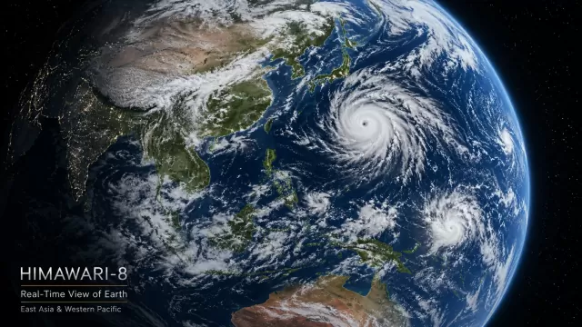
- Himawari-8 live
- GOES satellite images
you may have noticed something unusual about modern weather satellites.
The Earth almost never moves.
Clouds drift.
Typhoons rotate.
Storm systems evolve in real time.
But the satellite view itself remains fixed over the same region of the planet.
That’s because many of the world’s most important weather satellites operate in something called a geostationary orbit.
And without this special orbit, modern weather forecasting, real-time cloud imagery, and live Earth observation would be far less effective.
What Is a Geostationary Weather Satellite?
A geostationary satellite is a satellite that orbits Earth at approximately 35,786 kilometers above the equator.
At this exact altitude, the satellite travels around Earth at the same speed Earth rotates.
As a result, the satellite appears motionless relative to the surface below.
Instead of constantly moving across the planet like low Earth orbit satellites, geostationary satellites continuously observe the same hemisphere 24 hours a day.
This is why weather satellite systems such as:
- Himawari-8
- GOES-East
- GOES-West
- Meteosat
- GK-2A
always seem to show the same part of Earth.
They are essentially “parked” above the equator in space.
Why Are Weather Satellites Placed Above the Equator?
This is the key reason most weather satellites stay in equatorial geostationary orbit.
Earth rotates around its equator.
For a satellite to remain synchronized with Earth’s rotation and appear stationary, it must orbit within the same rotational plane.
That means:
A true geostationary satellite must orbit directly above the equator.
If the orbit tilted north or south, the satellite would appear to move across the sky instead of remaining fixed over one location.
The equatorial orbit allows weather satellites to continuously monitor regions like:
- the Pacific Ocean
- North America
- Europe
- East Asia
- Australia
without interruption.
Why Geostationary Orbit Is Perfect for Real-Time Weather Monitoring
The biggest advantage of geostationary satellites is continuity.
Weather changes constantly.
A typhoon can rapidly intensify within hours.
Thunderstorms can develop in minutes.
Cloud systems move across entire oceans every day.
Meteorologists need continuous observation to understand these changes in real time.
That’s why geostationary weather satellites are so important.
They can:
- monitor cloud movement continuously
- track hurricanes and typhoons in real time
- observe day-night transitions across Earth
- detect severe weather development
- provide near real-time satellite imagery updates
For example, satellites like Himawari-8 and GOES can update visible weather imagery every few minutes.
This allows forecasters to watch:
- typhoon eyes forming
- cloud bands tightening
- storm convection intensifying
- atmospheric rivers moving across oceans
frame by frame from space.
Without geostationary orbit, real-time weather forecasting would be much slower and less accurate.
Why Real-Time Satellite Imagery Feels So Fascinating
There’s something uniquely mesmerizing about watching Earth through geostationary weather satellites.
Unlike static Earth photos, real-time satellite imagery shows a living planet:
- clouds slowly moving across oceans
- typhoons rotating over the Pacific
- storms developing in real time
- sunlight shifting across Earth
- weather systems evolving hour by hour
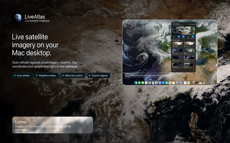
That feeling is actually one of the reasons I became interested in using weather satellite imagery as a desktop experience.
That idea eventually became LiveAtlas, a macOS app that turns live weather satellites into dynamic Earth wallpapers.
Instead of using static wallpapers, LiveAtlas displays real-time satellite imagery from systems like:
- Himawari-8
- GOES
- Meteosat
- GK-2A
directly on the Mac desktop.
As weather systems evolve over Earth, the wallpaper changes with them.
It transforms an ordinary desktop into a continuously updating view of the planet from space.