
What Is Himawari-8 Satellite?
When you look at a modern weather map showing swirling clouds over Asia and the Pacific Ocean, there’s a good chance you are looking at imagery captured by the Himawari-8 weather satellite.
But what exactly is Himawari-8, and why has it become so important for weather monitoring, climate observation, and even real-time Earth visualization applications?
⸻
The Meaning Behind “Himawari”
“Himawari” (ひまわり) means sunflower in Japanese. The name has been used for Japan’s geostationary weather satellite program for decades.
Japan Meteorological Agency operates the Himawari satellite series to monitor:
* Cloud movement
* Typhoons
* Atmospheric conditions
* Ocean weather patterns
* Severe storms across the Asia-Pacific region
Himawari-8 is one of the most advanced satellites in this series and marked a major leap forward in weather observation technology.
⸻
When Was Himawari-8 Launched?
Himawari-8 was launched on October 7, 2014, and became operational in 2015.
It was built by Mitsubishi Electric and positioned in geostationary orbit approximately 35,786 km above Earth.
Unlike low-orbit satellites that continuously move around the planet, Himawari-8 stays fixed relative to Earth’s rotation. This allows it to constantly observe the same region of the world.
Its coverage includes:
* Japan
* China
* Southeast Asia
* Australia
* Western Pacific Ocean
* Parts of Antarctica
This wide observation range makes it extremely valuable for tracking typhoons and large-scale cloud systems.
⸻
Why Is Himawari-8 Special?
One of the biggest upgrades introduced by Himawari-8 was image quality and refresh speed.
Older weather satellites often updated imagery every 30 minutes or longer. Himawari-8 dramatically improved this by providing:
* Full-disk Earth images every 10 minutes
* Regional updates as fast as every 2.5 minutes
* 16 spectral observation bands
* Higher spatial resolution
This means meteorologists can observe cloud development and storm behavior in near real-time.
The satellite’s Advanced Himawari Imager (AHI) can detect:
* Water vapor
* Surface temperature
* Ash clouds
* Storm structures
* Cloud altitude
* Atmospheric moisture
This level of detail is essential for modern weather forecasting.
⸻
The Stunning Visual Side of Himawari-8
Beyond meteorology, Himawari-8 also became widely appreciated for its breathtaking Earth imagery.
Because the satellite continuously observes the Asia-Pacific hemisphere, it produces incredibly detailed visualizations of:
* Rotating cloud systems
* Day-night transitions
* Seasonal weather changes
* Massive typhoons over the Pacific
Many space and weather enthusiasts enjoy watching Himawari imagery simply because it offers a live perspective of Earth’s atmosphere in motion.
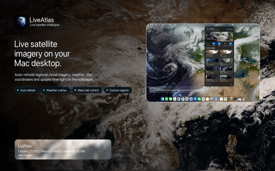
In recent years, some desktop applications and visualization tools have started using public Himawari imagery to create dynamic Earth views on macOS desktops. For example, apps like LiveAtlas quietly integrate real-time satellite imagery into desktop environments, allowing users to observe changing cloud patterns throughout the day without needing to open a weather website.
The appeal is less about traditional weather forecasting and more about ambient Earth visualization — turning live planetary data into part of the workspace itself.
⸻
How Accurate Is Himawari-8 for Weather Tracking?
Very accurate.
Himawari-8 is used operationally by meteorological agencies across the Asia-Pacific region and plays a major role in:
* Typhoon prediction
* Aviation weather monitoring
* Severe storm tracking
* Climate research
* Marine forecasting
Because it refreshes imagery so frequently, forecasters can monitor rapidly developing systems much more effectively than older satellites allowed.
For countries frequently affected by tropical storms, this speed can be critical.
⸻
Is Himawari-8 Data Public?
A large portion of Himawari-8 imagery is publicly accessible through weather agencies and scientific data platforms.
Developers, researchers, and visualization enthusiasts often use these datasets to build:
* Live weather maps
* Earth visualization tools
* Satellite wallpaper systems
* Educational applications
* Climate monitoring dashboards
This accessibility has helped create a growing ecosystem around real-time Earth observation.
⸻
The Future of Real-Time Earth Observation
Satellites like Himawari-8 represent more than weather forecasting technology.
They are part of a broader shift toward real-time planetary awareness — where atmospheric data, climate systems, and global cloud movement become continuously observable to anyone with an internet connection.
As visualization technology improves, Earth observation is increasingly moving beyond scientific institutions and into everyday digital experiences.
For many users, watching the living atmosphere of Earth unfold in real time is no longer just useful — it’s calming, immersive, and strangely beautiful.