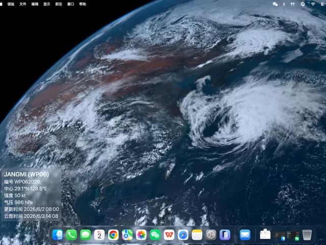
In recent days, JANGMI over the Northwestern Pacific has reminded me once again that weather is more than just a line of text in a phone notification, or a wind-circle icon inside a forecast app. Before anything else, it is a real mass of clouds — constantly rotating, evolving, and moving across the Earth.
According to publicly available tropical cyclone data, JANGMI was designated as Tropical Cyclone 06W in the Western Pacific during the 2026 season. It developed over the Philippine Sea in late May, gradually tracked northward, and later began affecting areas near Okinawa. The Korea Meteorological Administration’s typhoon advisory issued on May 30 also projected its movement toward the north and northeast, along with changes in intensity. By around June 1, military bases in Okinawa had already started preparing for the storm.
But what truly interests me is not the numbers at a specific moment. What fascinates me is the feeling that “weather is happening” when you look at satellite imagery.
On satellite images, a typhoon is not an abstract symbol. You can actually see its spiral rainbands, the denser cloud clusters near the center, the elongated moisture structures around the outer circulation, and the interaction between the storm and the surrounding atmosphere. Systems like JANGMI are especially interesting to observe. It was not a perfectly symmetrical “textbook” super typhoon, yet it clearly showed how a tropical cyclone organizes itself, strengthens, moves, and gradually changes shape.
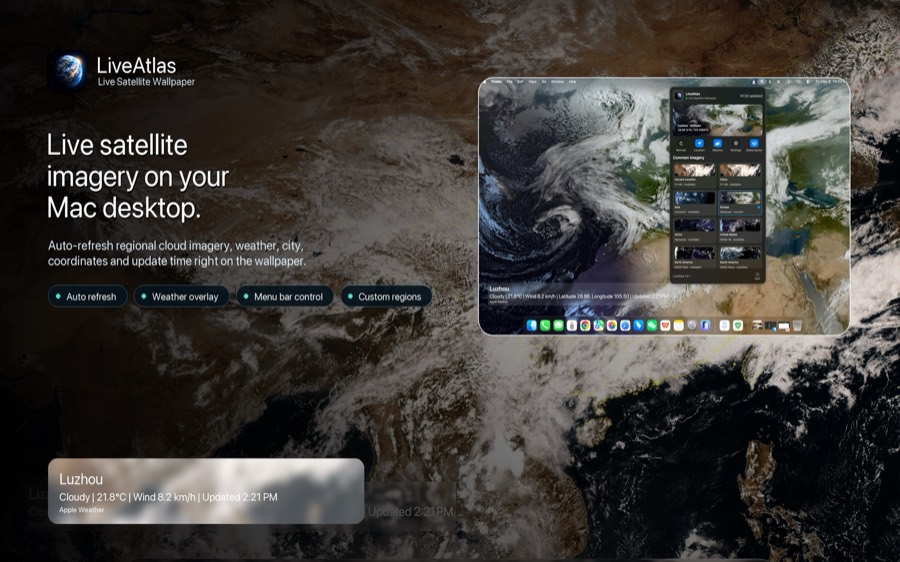
That is also one of the reasons why I created LiveAtlas.
I have always felt that desktop wallpapers do not have to be static images. For people who spend long hours in front of a Mac every day, the desktop can become a quiet information interface. It does not need to interrupt you, send notifications, or compete for attention. It simply stays in the background and gently reminds you that the Earth is constantly changing.
LiveAtlas does something very simple: it turns real-time or near real-time satellite imagery into a live macOS desktop wallpaper. You can choose different regions such as Asia, Europe, the Americas, Africa, Oceania, or the Arctic, allowing your desktop to update alongside cloud patterns and weather systems around the world.
When JANGMI was moving across the Northwestern Pacific, this became my favorite way to observe it. Instead of constantly refreshing forecast pages, I simply kept a space-view image of Earth on my desktop. During breaks from work, a quick glance was enough to notice how the cloud bands shifted, how the storm structure evolved, and how the overall weather pattern changed over time.
Of course, LiveAtlas is not a professional forecasting tool, nor should it replace official meteorological warnings or advisories. It is better described as an “Earth observation tool” — something for people who enjoy weather systems, satellite imagery, space-based perspectives, or simply want their Mac desktop to feel more alive.
Over time, I realized this experience has several surprisingly subtle benefits.
First, it makes weather feel more tangible.
When we say “a typhoon is coming,” it is easy to think only about warnings, rain, and wind speeds. But from satellite imagery, a typhoon becomes an entire atmospheric system in motion. You can see cloud bands wrapping into the center, outer clouds spreading outward, and the system interacting with nearby land and air masses. These visual changes are often far more intuitive than plain text descriptions.
Second, it avoids creating unnecessary anxiety.
Many weather apps rely heavily on alerts, badges, and constant notifications. LiveAtlas takes a quieter approach. It simply places Earth on your desktop and lets you observe it whenever you want. For me, that level of information density feels just right.
Third, it transforms the desktop into something more than decoration.
I enjoy beautiful wallpapers, but I enjoy wallpapers with a sense of time even more. Satellite imagery changes every day — sometimes every few hours. The desktop stops being a static picture and becomes a continuously updating window into the planet.
JANGMI is only one example. In the future there will be monsoon cloud systems, frontal bands, tropical disturbances, winter storms, and polar cloud formations. Not all of them will make headlines like a typhoon, but from space, every weather system has its own unique shape and character.
If you also enjoy observing weather, satellite imagery, or simply want a Mac desktop that feels more connected to the real Earth, you might enjoy trying LiveAtlas.
App Store:https://apps.apple.com/us/app/liveatlas/id6762602057
Official Website:https://www.liveatlas.top/
And finally, one important reminder: whenever severe weather such as typhoons or heavy rainfall occurs, always prioritize information from your local meteorological agencies and official warnings. LiveAtlas is designed for observing Earth — not for replacing professional forecasts.