Some show fast-moving cloud systems in near real-time.
Others reveal ultra-detailed Earth textures, polar ice, or cinematic full-globe imagery.
The answer is simple:
Different satellites are designed for different purposes.
In apps like LiveAtlas and other Earth visualization tools, each satellite mode creates a very different viewing experience — not because one is “better,” but because each one focuses on a different way of seeing our planet.
⸻
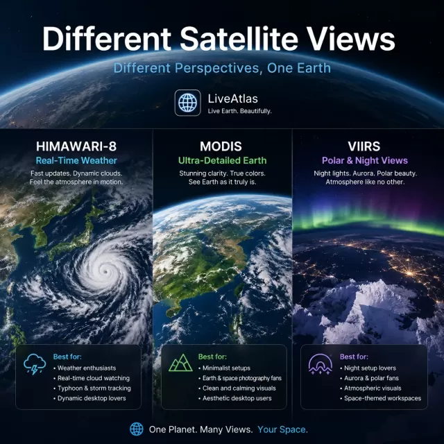
1. Himawari-8 Style Views
Best for Real-Time Weather Watching
Himawari-8 imagery is often the most “alive” looking.
These views focus on:
* Fast cloud movement
* Typhoons
* Atmospheric flow
* Large weather systems over the Pacific and Asia
The biggest characteristic is motion.
Cloud bands constantly evolve, storms rotate visibly, and the atmosphere feels dynamic from minute to minute.
For many users, this creates a calming “living Earth” effect on the desktop.
Best for:
* Weather enthusiasts
* People who enjoy dynamic visuals
* Users who want real-time cloud motion
* Typhoon and storm watchers
* Ambient desktop setups
This style feels more like watching the planet breathe in real time.
⸻
2. MODIS Earth Views
Best for Ultra-Detailed Earth Imagery
MODIS-based imagery feels completely different.
Instead of emphasizing rapid cloud animation, these views focus on:
* Earth detail
* Ocean color
* Ice structures
* Mountain textures
* High-resolution true-color visuals
The result looks closer to NASA photography than traditional weather radar.
Many users describe MODIS Earth imagery as:
* Cleaner
* More cinematic
* More immersive
* More “space photography” oriented
Clouds appear softer and more natural, while the Earth itself becomes the visual centerpiece.
Best for:
* Minimalist desktop users
* Space and Earth photography fans
* macOS aesthetic setups
* Users who prefer static beauty over constant motion
* People who enjoy ultra-clean visual environments
This mode is often favored by users who want their desktop to feel calm and atmospheric rather than highly active.
⸻
3. VIIRS Polar & Night Views
Best for Atmosphere and Mood
VIIRS imagery introduces another type of experience.
These views often excel at:
* Polar regions
* Night Earth imagery
* Aurora visualization
* Low-light atmosphere
* Dramatic cloud lighting
Compared to traditional weather views, VIIRS imagery can feel more emotional and cinematic.
Nighttime cloud formations, city light boundaries, and polar ice textures create a very different mood from daytime weather satellites.
Best for:
* Night desktop setups
* Aurora enthusiasts
* Users who enjoy atmospheric visuals
* Space-themed workspaces
* People who prefer darker desktop environments
These modes are less about tracking weather and more about appreciating the visual texture of Earth itself.
⸻
4. Why Different Users Prefer Different Satellite Modes
Interestingly, users tend to choose satellite imagery based on personality and workflow.
For example:
User Type Preferred Style
Weather enthusiasts Himawari-style live clouds
Minimalist Mac users MODIS Earth views
Night setup lovers VIIRS night imagery
Productivity-focused users Calm static Earth modes
Space & science fans Polar and true-color imagery
Some users want motion and energy.
Others want calmness and visual balance.
That’s why modern Earth visualization apps increasingly offer multiple viewing styles instead of a single satellite feed.
⸻
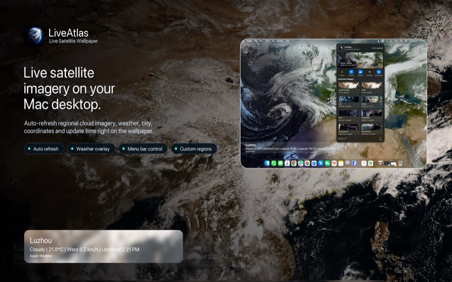
5. Satellite Imagery Is Becoming a Desktop Experience
In the past, satellite imagery mostly existed inside scientific tools and weather websites.
Today, many users simply enjoy having Earth quietly present in their workspace.
Instead of opening a weather app manually, live cloud systems, oceans, and atmospheric patterns can now become part of the desktop environment itself.
Applications like LiveAtlas explore this idea by turning different satellite perspectives into ambient desktop experiences — allowing users to choose whether they prefer dynamic cloud movement, ultra-detailed Earth imagery, or calm polar views.
The experience becomes less about checking the weather, and more about staying visually connected to the planet throughout the day.
⸻
Final Thoughts
No single satellite view is “the best.”
Each style reveals a different side of Earth:
* Himawari emphasizes movement
* MODIS emphasizes detail
* VIIRS emphasizes atmosphere
Together, they create multiple ways to experience our planet — not only as weather data, but also as visual art, ambient information, and a constantly changing living world.