Typhoon Eye and Satellite Cloud Images: How to Understand the Eye of a Storm from Space
Few weather patterns look as dramatic from space as a powerful typhoon.
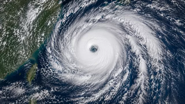
In satellite cloud images, a mature typhoon often appears as a massive spiral system over the ocean. At its center, there may be a small, nearly circular opening called the eye. Around that eye, thick white clouds form a dense ring known as the eyewall — the most intense part of the storm.
For beginners, the typhoon eye is one of the easiest storm features to recognize. But it is also one of the most misunderstood.
A clear eye does not mean the storm is weak. In many cases, it means the typhoon is highly organized and potentially very strong.
What Is the Eye of a Typhoon?
The eye of a typhoon is a relatively calm area near the center of a strong tropical cyclone. It is usually surrounded by towering thunderstorms and intense winds in the eyewall.
From space, the eye may look like a dark circular hole inside a bright white cloud shield. In visible satellite imagery, the eye can sometimes reveal the ocean surface below. In infrared satellite imagery, it may appear warmer than the surrounding cloud tops because the clouds inside the eye are lower or absent.
The eye can vary in size. Some typhoon eyes are large and easy to see, while others are small, cloud-filled, or difficult to identify.
Why Does a Typhoon Eye Form?
A typhoon forms over warm ocean water. As warm, moist air rises, it creates thunderstorms and lowers the pressure near the center of the system. Air spirals inward and upward around the storm.
In a strong and organized typhoon, air near the center can begin to sink. This sinking air warms and dries, reducing cloud formation in the very center. As a result, a clearer area may appear: the eye.
Around the eye, however, air is rising violently. This creates the eyewall, where the strongest winds and heaviest rainfall usually occur.
This is why a satellite image can show a calm-looking center surrounded by extremely dangerous weather.
How to Identify a Typhoon Eye in Satellite Cloud Images
When looking at a typhoon eye satellite image, search for a few key signs.
1. A Circular or Oval Center
The eye often appears as a round or oval feature near the center of the storm. It may look like a dark spot, a clear hole, or a warmer region depending on the type of satellite image.
A perfectly clear eye is usually easier to spot in strong, mature typhoons.
2. A Dense Ring of Clouds Around the Eye
The bright cloud ring surrounding the eye is the eyewall. This area contains the most intense thunderstorms in the typhoon.
In visible imagery, the eyewall may appear as a bright white ring. In infrared imagery, it may appear very cold because the cloud tops are extremely high.
3. Spiral Cloud Bands
Outside the eyewall, curved cloud bands often spiral into the storm center. These are called spiral rainbands.
They show the rotation and organization of the typhoon. The more symmetrical and tightly wrapped the bands appear, the more organized the storm may be.
4. Strong Central Symmetry
A powerful typhoon often has a balanced, circular structure. If the eye is centered and the cloud shield is symmetrical, the storm may be well organized.
If the eye is ragged, off-center, or hidden by clouds, the storm may be changing in strength or interacting with wind shear, land, or cooler water.
Visible vs Infrared Images of a Typhoon Eye
To understand a typhoon from space, it helps to compare visible and infrared satellite images.
Visible Satellite Images
Visible images show sunlight reflected by clouds and Earth’s surface. During the day, they can reveal cloud texture, eye shape, and spiral cloud structure very clearly.
In a visible image, the eye may look like a dark circular opening surrounded by bright white clouds.
Visible images are especially useful for seeing:
* the shape of the eye
* cloud texture around the eyewall
* spiral bands
* low-level cloud patterns
* storm symmetry
However, visible imagery depends on sunlight, so it is less useful at night.
Infrared Satellite Images
Infrared images detect heat. They can be used during both day and night.
In infrared imagery, high and cold cloud tops often indicate strong thunderstorms. Since the eye is usually warmer than the surrounding eyewall clouds, it can stand out clearly.
Infrared imagery is useful for identifying:
* cold cloud tops
* intense convection
* eyewall strength
* nighttime storm structure
* changes in storm intensity
A very cold, circular eyewall surrounding a warmer eye can be a sign of a strong tropical cyclone.
What the Eyewall Tells Us
The eyewall is one of the most important parts of a typhoon.
It surrounds the eye and contains the storm’s strongest winds, deepest convection, and heaviest rainfall. In satellite cloud images, the eyewall often appears as a bright, dense ring of clouds.
A well-defined eyewall can suggest that the typhoon has developed a strong inner core. This does not automatically give an exact wind speed, but it does show that the storm is organized.
Meteorologists use satellite imagery, aircraft data when available, radar, ocean observations, and numerical models together to estimate storm intensity. Satellite cloud images are one important piece of the puzzle.
What Are Spiral Rainbands?
Spiral rainbands are curved bands of clouds and storms that wrap around the typhoon.
They can extend far from the center and bring heavy rain, gusty winds, and changing weather conditions even before the eye approaches.
In satellite images, spiral bands help reveal the rotation of the storm. They also show how moisture is being pulled into the typhoon.
For beginners learning how to read typhoon satellite images, spiral rainbands are a useful feature to watch because they make the storm’s structure easier to understand.
Does a Clear Eye Always Mean a Stronger Typhoon?
A clear eye often appears in strong typhoons, but it should not be used as the only sign of intensity.
A storm can have a visible eye and still be weakening. Another storm may have a cloud-filled eye but remain dangerous. Sometimes the eye becomes temporarily hidden during structural changes, such as an eyewall replacement cycle.
Several factors can affect the eye’s appearance:
* wind shear
* dry air intrusion
* ocean temperature
* land interaction
* eyewall replacement
* storm size
* satellite viewing angle
* time of day
So while a clear typhoon eye is an important clue, it should be interpreted together with other satellite features.
What Is an Eyewall Replacement Cycle?
In very strong tropical cyclones, a new eyewall can sometimes form outside the original eyewall. Over time, the outer eyewall may replace the inner one. This is known as an eyewall replacement cycle.
During this process, the original eye may become less clear or disappear temporarily. The storm may weaken for a period, then sometimes strengthen again after the new eyewall becomes established.
From satellite imagery, this can appear as a changing eye shape, a larger eye, or multiple rings of convection around the center.
For weather enthusiasts, this is one of the most fascinating changes to watch in typhoon satellite imagery.
Why Typhoon Eyes Look So Beautiful from Space
The eye of a typhoon is visually striking because it combines order and power.
The storm may cover hundreds of kilometers, yet the center can appear almost perfectly circular. White cloud bands spiral around a calm-looking core. The ocean below may be visible through the eye, while the surrounding eyewall reaches high into the atmosphere.
This contrast makes typhoon satellite images both beautiful and serious.
They remind us that Earth’s atmosphere is dynamic, complex, and powerful.
How Satellite Imagery Helps Us Understand Typhoons
Satellite cloud images are essential because typhoons often form and intensify over open ocean, far from ground-based weather stations.
From space, satellites can monitor:
* storm formation
* cloud organization
* eye development
* eyewall structure
* rainband movement
* storm size
* interaction with land or other weather systems
* weakening or strengthening trends
For ordinary users, satellite images make these processes visible. For meteorologists, they provide critical information for monitoring tropical cyclones.
Bringing Typhoon Satellite Imagery into Daily Observation
Many people only check satellite images during major storms. But observing cloud patterns regularly can help you understand how weather systems develop over time.
A typhoon does not appear suddenly as a perfect spiral. It begins as a disturbance, becomes more organized, develops curved bands, builds a central core, and may eventually form an eye.
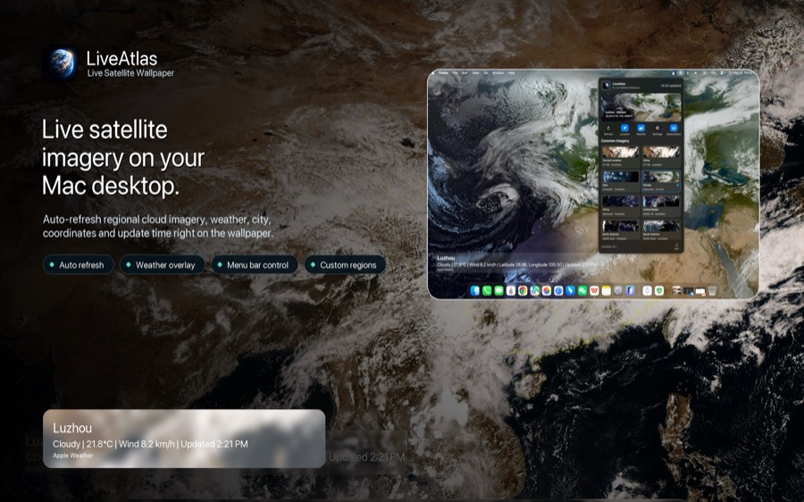
Apps and visual tools that display satellite imagery, such as LiveAtlas, can make this kind of observation more accessible. By watching cloud patterns across different regions, users can better appreciate how large-scale weather systems evolve from space.
Final Thoughts
The eye of a typhoon is one of the most recognizable features in satellite cloud images. It may look calm, but it is surrounded by some of the most dangerous weather in the storm.
To read a typhoon satellite image, look for:
* a circular or oval eye
* a dense eyewall
* spiral rainbands
* cold cloud tops
* storm symmetry
* changes over time
Once you understand these features, satellite imagery becomes much more than a beautiful view from space. It becomes a way to understand the structure, strength, and movement of one of Earth’s most powerful weather systems.