How to Read Satellite Cloud Images: A Beginner’s Guide to Understanding Earth from Space
Satellite cloud images can look beautiful, mysterious, and sometimes confusing.
At first glance, they may seem like simple pictures of white clouds over blue oceans and green land. But once you know how to read them, satellite cloud images become much more interesting. They can reveal storms, wind patterns, tropical cyclones, cold fronts, clear skies, moisture movement, and the daily rhythm of Earth’s atmosphere.
This beginner’s guide will help you understand how to read satellite cloud images and what to look for when viewing Earth from space.
What Are Satellite Cloud Images?
Satellite cloud images are pictures of Earth taken by weather satellites. These satellites observe the atmosphere from space and help us see cloud patterns across large areas.
Unlike a weather forecast icon that shows “sunny” or “rainy,” satellite imagery shows the real structure of the atmosphere. You can see where clouds are forming, how weather systems are moving, and how different regions of Earth are changing throughout the day.
For beginners, the most important thing to understand is this:
Satellite images are not just pretty pictures. They are visual records of Earth’s weather in motion.
Why Clouds Look Different from Space
Clouds look very different from space compared with what we see from the ground.
From below, you may only see a gray sky or scattered white clouds. From space, you can see the entire shape of a weather system. A small rainy day in one city may be part of a much larger cloud band stretching across hundreds or even thousands of kilometers.
Cloud appearance depends on several factors:
* cloud thickness
* cloud height
* sunlight angle
* land or ocean background
* time of day
* type of satellite image
* storm strength
Bright white clouds often appear thick or high. Thin clouds may look softer or more transparent. Large spiral shapes may indicate organized storm systems. Long cloud bands can suggest fronts or large-scale atmospheric movement.
Once you begin noticing these patterns, satellite images become easier to read.
Visible Satellite Images vs Infrared Satellite Images
One of the most common beginner questions is the difference between visible satellite images and infrared satellite images.
Visible Satellite Images
Visible satellite images are similar to what a camera might see from space. They use reflected sunlight, so they work best during the daytime.
In visible imagery, clouds usually appear white, oceans appear dark blue, and land appears green, brown, or tan depending on the region.
Visible satellite images are useful for observing:
* daytime cloud shapes
* coastlines and land features
* storm structure
* cloud texture
* fog and low clouds
* snow-covered land
However, visible images depend on sunlight. At night, they become much less useful.
Infrared Satellite Images
Infrared satellite images detect heat rather than reflected sunlight. This makes them useful both day and night.
In infrared imagery, colder cloud tops often indicate higher clouds. Very cold cloud tops can suggest strong thunderstorms or deep convection.
Infrared images are useful for observing:
* nighttime cloud cover
* storm intensity
* high cloud tops
* tropical cyclone structure
* cold cloud regions
* large weather systems
A simple way to remember the difference:
Visible imagery shows how clouds look in sunlight.
Infrared imagery helps reveal cloud temperature and height.
For beginners, comparing visible and infrared satellite images of the same region is one of the fastest ways to understand how weather satellites work.
How to Identify Common Cloud Patterns
When reading satellite cloud images, do not try to understand everything at once. Start by looking for basic cloud patterns.
1. Large Cloud Bands
Long, wide cloud bands often indicate large-scale weather systems. They may be connected to fronts, moisture transport, or storm development.
These cloud bands can stretch across oceans, continents, or entire regions.
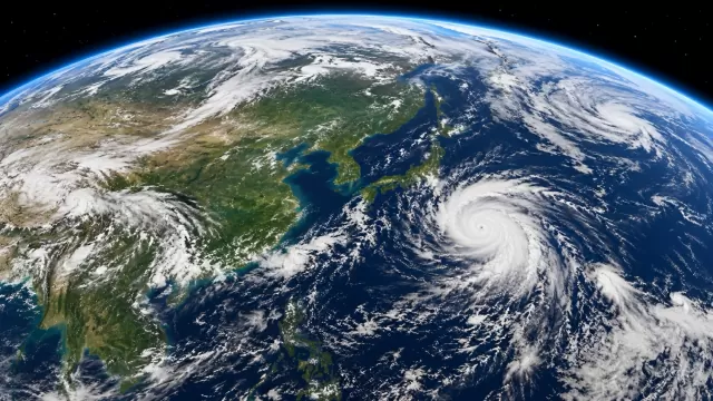
2. Spiral Cloud Systems
A spiral cloud pattern is one of the easiest features to recognize. It often suggests a rotating weather system.
In the tropics, a strong spiral structure may indicate a tropical storm or typhoon. In mid-latitudes, spiral cloud systems may be connected to low-pressure systems.
3. Bright White Cloud Clusters
Very bright cloud clusters may indicate thick or high clouds. In infrared imagery, these may also represent cold cloud tops.
These clusters are often associated with thunderstorms or intense rainfall areas.
4. Scattered Small Clouds
Small, scattered clouds over land or ocean are often fair-weather cumulus clouds. They can appear as small dots or patches.
These clouds usually do not indicate major storms, but they can reveal local heating and atmospheric instability.
5. Clear-Sky Regions
Dark or cloud-free areas are also important. Clear regions may indicate dry air, stable weather, or high-pressure systems.
Beginners often focus only on clouds, but clear areas can tell you just as much about the atmosphere.
How to Spot Storms on Satellite Images
Storms are among the most interesting features to observe in satellite imagery.
To identify storms, look for:
* dense cloud clusters
* circular or spiral organization
* bright cold cloud tops
* expanding cloud shields
* curved rain bands
* rapid changes between image updates
A tropical cyclone or typhoon often has a rounded structure, curved cloud bands, and sometimes a visible eye. However, not every spiral cloud pattern is a typhoon. Some weaker low-pressure systems can also create rotation.
Strong thunderstorms may appear as bright white or very cold cloud tops in infrared imagery. These clouds reach high into the atmosphere and can indicate intense weather below.
How to Read Cloud Movement
Satellite images become more useful when viewed over time.
A single image shows the current cloud pattern. A sequence of images shows movement.
When looking at satellite image loops, pay attention to:
* direction of cloud movement
* speed of cloud systems
* growth or weakening of storms
* rotation around low-pressure areas
* changes in cloud thickness
* clouds forming during the day and fading at night
Cloud movement can reveal wind flow at different levels of the atmosphere. High clouds may move in one direction while lower clouds move differently. This is one reason satellite loops are so valuable for understanding weather.
What Cloud Texture Can Tell You
Cloud texture is another useful clue.
Smooth cloud sheets often suggest layered clouds. These may be connected to widespread stable weather or large cloud shields.
Bumpy or bubbling cloud textures may suggest stronger vertical development. These can be associated with showers, thunderstorms, or unstable air.
Thin, wispy clouds are often high-level clouds. They may appear stretched or feather-like because of strong upper-level winds.
By looking at texture, you can begin to understand whether clouds are shallow, layered, or vertically developed.
Why Oceans Are Important in Satellite Cloud Images
Oceans play a major role in satellite weather imagery.
Many large weather systems form over water. Tropical storms and typhoons often develop over warm ocean regions. Moisture from oceans feeds cloud formation and rainfall systems.
In satellite images, ocean areas can reveal:
* tropical cyclone formation
* marine cloud fields
* moisture movement
* storm tracks
* clear dry zones
* cloud streets caused by wind
For anyone learning how to understand weather satellite images, ocean regions are worth watching closely.
Why Satellite Images Are Useful for Everyday Users
Satellite imagery is not only for meteorologists.
It can also be useful for students, teachers, travelers, weather enthusiasts, photographers, pilots, sailors, developers, and anyone curious about Earth.
Satellite cloud images help people understand:
* where storms are forming
* how weather changes over time
* why some regions are cloudy while others are clear
* how large weather systems move
* how Earth looks as a connected atmosphere
Even if you do not need professional forecasting, satellite images can deepen your awareness of the planet.
Bringing Satellite Cloud Imagery into Daily Life
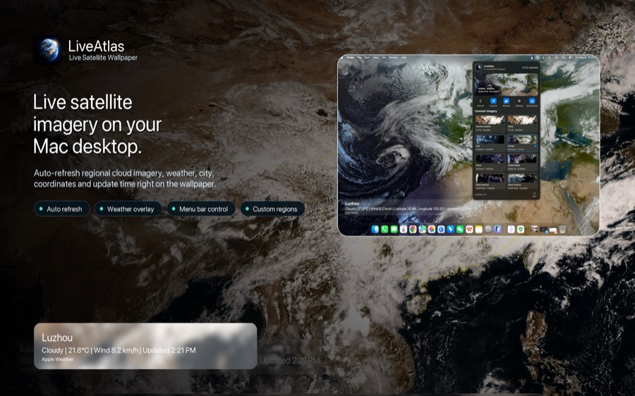
Many people only see satellite images when checking a weather website. But satellite imagery can also become part of a daily visual experience.
For example, LiveAtlas brings real satellite cloud imagery to the Mac desktop, turning Earth’s changing atmosphere into a calm, dynamic wallpaper. Instead of viewing satellite imagery only when checking the weather, you can quietly observe cloud patterns as part of your workspace.
This is especially useful for people who enjoy geography, Earth observation, weather systems, or simply a more meaningful desktop background.
Final Thoughts
Learning how to read satellite cloud images does not require professional training. You only need to know what to look for.
Start with simple questions:
Where are the clouds thickest?
Are they scattered or organized?
Do they form bands, spirals, or clusters?
Are they growing or fading over time?
Is the image visible or infrared?
What does the cloud movement suggest?
The more you observe, the more patterns you will recognize.
Satellite cloud images are more than weather pictures. They are a way to see Earth as a living, changing system — one cloud pattern at a time.