Himawari-8 vs GOES: Why Earth Looks Different Depending on the Satellite
If you’ve ever explored real-time Earth satellite imagery, you’ve probably noticed something strange:
Some cloud maps look incredibly sharp and colorful, while others appear softer, darker, or focused on completely different weather systems.
That difference isn’t just image processing.
It often comes down to which satellite captured the image.
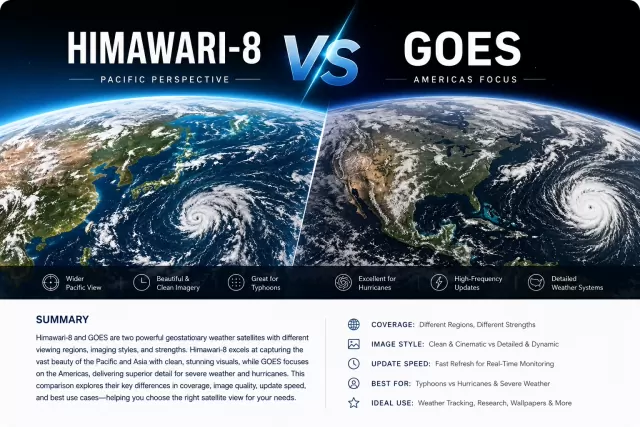
Two of the most widely used weather satellites today are Japan’s Himawari-8 and the American GOES series. Both continuously observe Earth from geostationary orbit, both provide stunning real-time cloud imagery, and both power countless weather websites and visualization tools around the world.
But despite serving similar purposes, they produce surprisingly different viewing experiences.
This article explores the real-world differences between Himawari-8 and GOES imagery — from visual style and update frequency to geographic strengths and ideal use cases.
⸻
What Is Himawari-8?
Himawari 8 is a Japanese geostationary weather satellite operated by the Japan Meteorological Agency.
Positioned above the equator over East Asia and the Pacific Ocean, Himawari-8 constantly monitors:
* Japan
* China
* Southeast Asia
* Australia
* The Western Pacific
* Typhoon activity across the Pacific basin
It became famous among weather enthusiasts because of its exceptionally clean and visually striking imagery.
Compared to many older weather satellites, Himawari-8 introduced:
* Higher spatial resolution
* Faster refresh intervals
* More spectral channels
* Sharper visible imagery
* More dynamic infrared color rendering
For many people, Himawari imagery was the first time satellite weather maps looked beautiful rather than purely scientific.
⸻
What Is GOES?
GOES stands for Geostationary Operational Environmental Satellite.
The GOES system is operated by National Oceanic and Atmospheric Administration and covers the Americas and Atlantic region.
Modern GOES satellites include:
* GOES-East
* GOES-West
Together they observe:
* North America
* South America
* The Atlantic Ocean
* The Pacific coast
* Major hurricane systems
GOES imagery powers much of the weather coverage seen across:
* U.S. television weather broadcasts
* NOAA weather platforms
* Hurricane tracking systems
* Aviation forecasting systems
The modern GOES-R generation dramatically improved image quality and scanning speed compared to earlier generations.
⸻
Why Do Their Images Look So Different?
At first glance, both systems seem similar:
* Both are geostationary
* Both monitor weather continuously
* Both capture visible and infrared imagery
Yet their output often feels visually distinct.
Here’s why.
⸻
1. Geographic Perspective Changes Everything
The biggest difference is location.
Himawari-8 sits above East Asia and the Western Pacific.
GOES-East and GOES-West focus on the Americas and Atlantic/Pacific regions.
That changes:
* cloud angles
* sunlight direction
* ocean coloration
* atmospheric haze
* storm visibility
For example:
Himawari-8 excels at:
* Pacific typhoons
* Japanese weather systems
* Massive ocean cloud formations
* Sunrise and sunset transitions across Asia
GOES excels at:
* Atlantic hurricanes
* North American storm systems
* Gulf Coast weather
* U.S. thunderstorm development
Different geography naturally creates different visual moods.
⸻
2. Himawari Imagery Often Looks “Cleaner”
Many users notice Himawari imagery appears:
* smoother
* brighter
* more cinematic
This comes from several factors:
* strong visible-light processing
* ocean-heavy viewing regions
* fewer landmass interruptions
* excellent atmospheric clarity over the Pacific
Large uninterrupted ocean regions allow cloud systems to stand out dramatically.
The result can feel almost artistic.
This is one reason Himawari imagery became extremely popular in:
* desktop wallpapers
* weather livestreams
* Earth visualization projects
* atmospheric timelapses
⸻
3. GOES Is Exceptional for Severe Weather Tracking
GOES imagery shines when tracking rapidly evolving weather systems across the Americas.
Its strengths include:
* hurricane monitoring
* thunderstorm evolution
* atmospheric river tracking
* severe weather forecasting
The GOES-R generation introduced rapid scanning modes capable of observing storm development at extremely short intervals.
This makes GOES invaluable for:
* meteorologists
* aviation forecasting
* emergency weather monitoring
* real-time storm analysis
If you regularly follow U.S. hurricanes or major North American storms, GOES imagery is often the preferred source.
⸻
4. Infrared Imagery Styles Are Different
Infrared satellite imagery can look wildly different depending on processing style.
Both Himawari and GOES capture thermal infrared data, but platforms often render them differently.
Himawari infrared imagery often emphasizes:
* vivid color gradients
* smooth cloud-top textures
* visually dramatic storm contrast
GOES infrared imagery often prioritizes:
* meteorological readability
* temperature differentiation
* storm structure analysis
Neither is “better.”
They simply optimize for different viewing experiences.
⸻
5. Update Frequency Matters
One of the most important improvements in modern weather satellites is refresh speed.
Older satellites sometimes updated every 30 minutes or longer.
Modern systems now provide much faster refresh intervals.
Both Himawari-8 and modern GOES satellites can produce near real-time imagery updates, making cloud movement feel alive rather than static.
This dramatically improves:
* storm visualization
* cloud animation smoothness
* desktop live wallpapers
* timelapse generation
Fast refresh rates are one reason satellite imagery has become increasingly popular outside traditional meteorology communities.
⸻
Which Satellite Produces Better Earth Wallpapers?
This depends entirely on personal preference.
Many users prefer Himawari for wallpapers because:
* Pacific cloud systems look dramatic
* imagery feels cleaner
* ocean-heavy compositions appear minimalist
* sunrise lighting over Earth looks stunning
Others prefer GOES because:
* North America is more recognizable
* storms feel more dynamic
* weather systems appear more intense
* cloud evolution is highly detailed
In practice, the best experience often comes from switching between both depending on:
* season
* storm activity
* time of day
* personal aesthetic preference
⸻
Which One Is More Accurate?
This is a common misconception.
People often assume sharper imagery means “more accurate.”
In reality:
* both Himawari and GOES are scientifically advanced systems
* both provide highly reliable meteorological observations
* visual appearance is heavily influenced by processing and rendering
What changes most is:
* perspective
* color mapping
* atmospheric conditions
* visualization style
A visually softer image is not necessarily lower quality.
⸻
Why Satellite Imagery Became Popular Outside Weather Communities
A decade ago, satellite imagery was mostly used by:
* meteorologists
* government agencies
* aviation professionals
Today it has become mainstream visual media.
Why?
Because modern satellites now produce imagery that is:
* high resolution
* visually beautiful
* continuously updated
* globally accessible
People increasingly use satellite imagery for:
* desktop environments
* ambient displays
* live streams
* educational content
* climate awareness
* artistic visualization
Watching cloud systems move across Earth in real time creates a unique sense of scale and atmosphere that static wallpapers cannot replicate.
⸻
Choosing Between Himawari and GOES
Here’s the simplest way to think about it.
Choose Himawari if you love:
* Pacific cloud formations
* East Asia weather systems
* cinematic Earth imagery
* smoother cloud visuals
* minimalist ocean-heavy compositions
Choose GOES if you prefer:
* Atlantic hurricanes
* North American weather
* dynamic storm systems
* severe weather tracking
* fast-changing atmospheric activity
Many weather enthusiasts ultimately use both.
⸻
Final Thoughts
Himawari-8 and GOES represent two of the most advanced weather observation systems ever deployed.
Although they serve similar scientific purposes, they create very different visual experiences depending on:
* geography
* lighting
* atmosphere
* processing style
* weather patterns
That diversity is part of what makes modern Earth observation so fascinating.
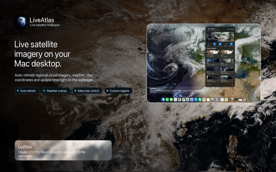
For users who enjoy watching real-time cloud movement directly from their desktop, tools like LiveAtlas make it possible to experience both Himawari and GOES imagery as dynamic live wallpapers on macOS — turning constantly changing satellite data into an ambient view of Earth itself.